Max viewable distance for maps

Member
βœ”οΈ HL Verified
πŸš‚ Steam Linked
Joined
Jan 2, 2003
Messages
116
Best answers
0
Here I am 15 years later and I really regret never finishing my babadi map from years past. https://forum.esforces.com/threads/babadis-lair-map.36070/page-5

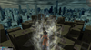
One of the major issues I was having is setting the max view distance so I can see the entire play field. ESF_CITY is MUCH bigger than my map and does a wonderful job of displaying the entire play field. However, I cannot for the life of me figure out how. I even decompiled esf_city and recompiled a crap version of it to see if the view distance changes, and it works perfectly. So I honestly don't know where the map is setting this variable

Here are the only settings I know of:
ESF_CITY
map properties/max viewable distance = 14000
vis.exe set to -maxdistance 500000 instead of 0

Any help trying to figure this out would be appreciated so I can finally finish this map

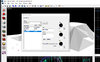
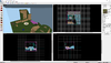
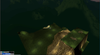
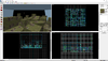
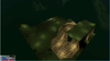
Here are some screen caps to show what I'm dealing with
 

Attachments

ESF Head Team Mapper
πŸ‘‘ Administrator
🌠 Staff
βœ”οΈ HL Verified
πŸš‚ Steam Linked
πŸ‚ Regular
Joined
Dec 25, 2001
Messages
3,619
Best answers
0
Location
Germany
Wow.. blast from the past. Sorry for being mean 15 yerars ago πŸ˜‚
maxdistance 500k is probably too much for the compiler to handle, the original max map size was 4096 (+/- 4096 so 8192 units total? Not sure, can't remember). Probably try 16384 (power of 2 numbers).
I still have all the compile tools and .bat files I used for the official 1.2 maps (mine at least) so I'll dig that up tonight when I'm back home.

I hear there are alternatives to hammer "now" that allow for 32k unit sized maps ... together with updated zhlt builds I assume. Those would probably have ways to increase the distance as well. Never tested that stuff - haven't had to touch Hammer in over 10 years
Random google result https://sites.google.com/site/gshltools/mapping-tools
 
Member
βœ”οΈ HL Verified
πŸš‚ Steam Linked
Joined
Jan 2, 2003
Messages
116
Best answers
0
No worries man, we were all young(er) at the time, it happens lol

Checking out the "Sledge Editor" it's kind of life hammer but useful updates like model rendering and texture rendering for water (see through). So far I like it better as it auto saves 5 versions of your work. I came across an old mapping error with hammer editor off the SDK where sometimes when you export to .map, you goto load the file later and it's corrupt. Lost an hours worth of work already lol

I appreciate the information, let me know if you find the compile settings, I'm eager to see if there's something more to learn here

I'll try that max distance too, this issue has always left me scratching my head


Update: tried an updated version of zhlt
set max view distance in map properties to 4096
-maxdistance for vis didn't use

It's about the sameπŸ€”

Not sure what to do at this point
 

Attachments

Last edited:
ESF Head Team Mapper
πŸ‘‘ Administrator
🌠 Staff
βœ”οΈ HL Verified
πŸš‚ Steam Linked
πŸ‚ Regular
Joined
Dec 25, 2001
Messages
3,619
Best answers
0
Location
Germany
Oooh right .. I totally forgot to check those compile settings πŸ˜… I'll put it in my calendar so my phone will remind me later :)
 
ESF Head Team Mapper
πŸ‘‘ Administrator
🌠 Staff
βœ”οΈ HL Verified
πŸš‚ Steam Linked
πŸ‚ Regular
Joined
Dec 25, 2001
Messages
3,619
Best answers
0
Location
Germany
ok, so I checked some of the old .bat full compile files and there is really nothing special in there
Code:
hlcsg.exe  -estimate -hullfile D:\Steam\Hammer\12hulls.txt -cliptype precise -texdata 8192 -nowadtextures "D:\Steam\s2k_maps\kamehouse\esf_kamehouse_test"
hlbsp.exe  -estimate -texdata 8192 -maxnodesize 4096 "D:\Steam\s2k_maps\kamehouse\esf_kamehouse_test"
hlvis.exe  -estimate -texdata 8192 -full -low "D:\Steam\s2k_maps\kamehouse\esf_kamehouse_test"
hlrad.exe  -estimate -texdata 8192 -low "D:\Steam\s2k_maps\kamehouse\esf_kamehouse_test"
pause
Code:
hlcsg.exe  -estimate -texdata 8192 -hullfile D:\Steam\Hammer\hulls.txt -cliptype precise -nowadtextures "D:\Steam\s2k_maps\cave\esf_cave"
hlbsp.exe  -estimate -texdata 8192 -maxnodesize 4096 "D:\Steam\s2k_maps\cave\esf_cave"
hlvis.exe  -estimate -texdata 8192 -full -low "D:\Steam\s2k_maps\cave\esf_cave"
hlrad.exe  -estimate -texdata 8192 -low -bounce 24 -smooth 90 -extra "D:\Steam\s2k_maps\cave\esf_cave"
pause
However, I did remember there was something about view distance in the map itself, thats probably what you're missing (menu bar Map -> Map Properties)
EDIT .. just read you already set that. Try a power of 2 value anyways.. that might help
maxrange.jpg
 
Member
βœ”οΈ HL Verified
πŸš‚ Steam Linked
Joined
Jan 2, 2003
Messages
116
Best answers
0
Thanks for looking into all of that. I figured out the issue

For some reason the raw value in my map properties was "maxrange" not "MaxRange"

I'm using this version of the FGD (maybe it's outdated now?)

Code:
//

// Earth Special forces game definition file (.fgd)

// Version beta 1

// For Worldcraft 3.3 and above, and Half-Life 1.0.0.9 and above

// Last update: 1-10-2001

//

// by Herwin 'harSens' van Welbergen
but in the worldspawn class it only accepts one value which IS case sensitive :O
Code:
@SolidClass = worldspawn : "World entity"
[
    message(string) : "Map Description / Title"
    skyname(string) : "environment map (cl_skyname)"
    light(integer) : "Default light level"
    WaveHeight(string) : "Default Wave Height"
    MaxRange(string) : "Max viewable distance" : "4096"
]
I appreciate your help on this
 
Last edited:

Users who are viewing this thread

Top Bottom